Version:

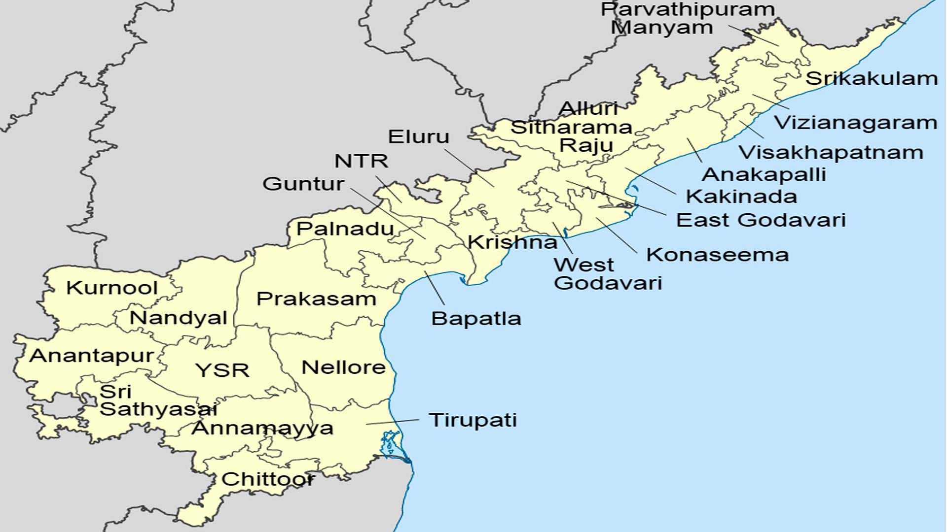 Andhra Pradesh Map With 26 Districts
Andhra Pradesh, located on the southeastern coast of India, is the country’s eighth-largest state by area and tenth-largest by population. Its capital and largest city is Amaravati, a planned city near Vijayawada. Renowned for its rich cultural heritage, Andhra Pradesh is home to various historical sites, temples, and festivals. The state boasts a diverse geography, encompassing coastal regions, fertile plains, and the Eastern Ghats mountain range. Agriculture is a significant economic driver, with rice being a staple crop. Andhra cuisine, famous for its spicy flavors, contributes to the state’s vibrant culinary heritage. With a dynamic blend of tradition and modernity, Andhra Pradesh plays a vital role in India’s economic and cultural landscape.
List of Districts of Andhra Pradesh
1. Srikakulam (SR)
2. Parvathipuram Manyam (PM)
3. Vizianagaram (VZ)
4. Visakhapatnam (VS)
5. Alluri Sitharama Raju (AS)
6. Anakapalli (AK)
7. Kakinada (KK)
8. East Godavari (EG)
9. Dr. B. R. Ambedkar Konaseema (KN)
10. Eluru (EL)
11. West Godavari (WG)
12. NTR (NT)
13. Krishna (KR)
14. Palnadu (PL)
15. Guntur (GU)
16. Bapatla (BP)
17. Prakasam (PR)
18. Sri Potti Sriramulu Nellore (NE)
19. Kurnool (KU)
20. Nandyal (NN)
21. Anantapur (AN)
22. Sri Sathya Sai (SS)
23. Kadapa (CU)
24. Annamayya (AM)
25. Tirupati (TR)
26. Chittoor (CH)
Population : 162,970 km2 (62,920 sq mi)
Capital : Amaravati
Largest city : Visakhapatnam